- Thumbnail
- Resource ID
- eb28e989-6f6a-11e9-8d7d-000d3ab6a624
- Title
- TM-BRB_Oceanographic and Meteorological Stations-2017
- Date
- May 5, 2019, 2:21 p.m., Publication
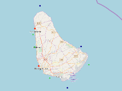
- Abstract
- This dataset displays existing oceangraphic and meteorological station locations located around the island of Barbados. These stations are categorised into three categories. These are Acoustic Wave and Current Profilers, Sea Level Stations and Directional Wave Buoys. This data was provided by the Coastal Zone Management Unit of Barbados ca.2017.
- Edition
- --
- Owner
- gridanode
- Point of Contact
- devrsgis@gmail.com
- Purpose
- --
- Maintenance Frequency
- None
- Type
- not filled
- Restrictions
- None
- None
- License
- None
- Language
- eng
- Temporal Extent
- Start
- --
- End
- --
- Supplemental Information
- No information provided
- Data Quality
- --
- Extent
-
- long min: -59.6529666700
- long max: -59.4172500000
- lat min: 13.0180000000
- lat max: 13.3570500000
- Spatial Reference System Identifier
- EPSG:900913
- Keywords
- no keywords
- Category
- None